

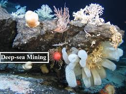
1. Deep-Sea Mining: Uncovering Lasting Ecological Impacts
Context: A recent study published in Nature, titled ‘Long-term Impact and Biological Recovery in a Deep-Sea Mining Track,’ reveals alarming findings about the effects of deep-sea mining. Conducted by scientists from Britain’s National Oceanography Centre, the research shows that an area of the Pacific Ocean seabed mined over 40 years ago has not fully recovered.
The results arrive at a critical time, as 36 countries recently gathered at a UN International Seabed Authority (ISA) meeting in Jamaica to debate whether mining companies should be permitted to extract valuable metals from the ocean floor.
What is Deep-Sea Mining?
Deep-sea mining refers to the extraction of valuable minerals and metals from the ocean floor, often located at depths beyond 200 meters. The process is divided into three main categories:
- Collecting Polymetallic Nodules: Harvesting metal-rich rocks scattered across the ocean floor.
- Mining Seafloor Sulphide Deposits: Extracting materials from hydrothermal vents, often rich in precious metals.
- Removing Cobalt Crusts: Stripping minerals from underwater mountains and volcanic structures.
Why It Matters:
Deep-sea mining is attracting interest because of its potential to provide essential materials such as nickel, cobalt, rare earth elements, and copper—all critical for technologies like renewable energy systems, electric vehicles, and everyday electronics.
Technological Innovations:
The technology for deep-sea mining is still evolving, with companies exploring methods such as:
- Vacuum-based Extraction: Using massive pumps to collect materials from the seabed.
- AI-Driven Robots: Deploying sophisticated machines to selectively gather polymetallic nodules.
- Underwater Mining Machines: Designed to extract resources from underwater mountains and volcanic regions.
Strategic Importance:
With onshore reserves depleting and the global demand for critical minerals rising, governments and corporations are increasingly eyeing the deep sea as the next frontier for resource extraction.
Key Findings of the Study
The study focused on a small-scale mining experiment conducted in 1979 within a section of the Pacific Ocean seafloor. Researchers examined an 8-meter strip of seabed during an expedition in 2023 to assess the long-term impacts.
Major Findings:
- Long-Term Damage: Mining led to significant sediment disruption and a decline in larger marine species, indicating that the ecosystem has not fully recovered even after four decades.
- Partial Recovery: While some species are beginning to recolonize, the process is slow and incomplete, raising concerns about the long-term viability of deep-sea ecosystems.
- Broader Environmental Concerns: Previous studies have highlighted additional negative effects of deep-sea mining, such as:
- Harmful Noise and Vibrations
- Sediment Plumes disrupting habitats
- Light Pollution impacting deep-sea species
A 2023 study published in Current Biology concluded that deep-sea mining significantly reduces animal populations and has broader ecological impacts than previously estimated.
Implications for Policy and Regulation:
The findings of this study are expected to play a crucial role in shaping future regulations by the International Seabed Authority (ISA).
Key Takeaways:
- The research suggests that while partial recovery is possible, full restoration of deep-sea ecosystems could take decades or longer.
- Data from this study contributes to the Seabed Mining and Resilience to Experimental Impact (SMARTEX) project, which aims to support informed decision-making about the ecological and societal impacts of deep-sea mining.
The Future of Deep-Sea Mining: Clarion Clipperton Zone (CCZ):
The Clarion Clipperton Zone (CCZ) is a mineral-rich region in the North Pacific Ocean, located between Hawaii and Mexico. It is known for its abundance of polymetallic nodules containing valuable minerals such as:
- Manganese
- Nickel
- Copper
- Cobalt
These materials are essential for manufacturing electric vehicles, solar panels, and other clean energy technologies.
The Debate Continues:
As interest in deep-sea mining grows, the ISA is currently evaluating whether and under what conditions mining should be allowed. The recent study adds substantial weight to the argument for a moratorium on deep-sea mining, particularly in ecologically sensitive areas like the CCZ.
Conclusion: A Call for Precaution:
The findings underscore the lasting impact of deep-sea mining on fragile marine ecosystems. While technological advancements and resource demands continue to drive interest in deep-sea mining, the long-term ecological risks cannot be ignored.
Future regulations must be guided by robust scientific research, prioritizing sustainability, biodiversity protection, and responsible resource management.
2. Sarhul Festival: Jharkhand’s Grand Celebration of Nature and Adivasi Culture
Context: The Adivasi communities of Jharkhand and the Chhotanagpur region are set to celebrate the Sarhul Festival on April 1, 2025. This grand occasion marks the New Year and the much-anticipated arrival of spring.

What is Sarhul?
Sarhul is a New Year festival celebrated by the tribal communities of Jharkhand as part of the Sarna religion. Held in the Hindu month of Chaitra, it occurs three days after the new moon. The festival is a vibrant celebration of spring and a reverent homage to nature.
Nature Worship at the Heart of Sarhul:
- The term Sarhul literally means “worship of the Sal tree”. The Sal tree is considered the abode of Sama Maa, the village-protecting deity. This festival, deeply rooted in nature worship, reflects the Adivasi’s profound connection to the environment.
Symbolizing the Union of Sun and Earth:
- Sarhul symbolizes the harmonious union of the Sun and the Earth. The pahan (male priest) represents the Sun, while his wife, the pahen, symbolizes the Earth. This connection highlights the importance of sunlight and soil for sustaining life.
A Festival Celebrating Life’s Cycle:
- Sarhul marks the renewal of life. Only after the rituals are completed do Adivasis commence agricultural activities such as ploughing, sowing, and forest gathering. This tradition emphasizes the festival’s deep-rooted ties to nature and sustenance.
Diverse Traditions Among Tribes:
- While Sarhul is celebrated by various tribes, including the Oraon, Munda, Santal, Khadia, and Ho, each group has its own unique customs and names for the festival.
From Hunting to Agriculture:
- Originally focused on hunting, the festival has evolved over time into an agriculture-based celebration, mirroring the changing lifestyle of Adivasis in the Chhotanagpur region.
Sarhul’s Journey Across Lands:
- During the 19th and early 20th centuries, Adivasi communities took Sarhul with them when they were sent as indentured laborers. As a result, Sarhul is now celebrated in places like Assam’s tea gardens, the Andaman and Nicobar Islands, Nepal, Bangladesh, and Bhutan.
The Three-Day Celebration:
Day One: Preparations
- The festival kicks off with decorations at homes and Sarna Sthals (sacred groves), featuring triangular red and white Sama flags. The pahan observes a fast and collects ceremonial water, while the community prepares the sacred sites and gathers Sal flowers.
Day Two: Main Rituals
- At the Sarna Sthal, villagers offer Sal flowers to the deity and sacrifice a rooster to ensure prosperity. The pahan sprinkles holy water while villagers perform traditional dances like Jadur, Gena, and Por Jadur. Young men participate in ceremonial fishing and crab-catching.
Day Three: Community Feast and Blessings
- The festival concludes with a grand community feast, featuring handia (rice beer) and traditional dishes. The pahan blesses the villagers, marking the end of the celebrations.
Transformation Over the Years:
Evolving Symbol of Identity:
- In the 1960s, Baba Karthik Oraon, a notable Adivasi leader, initiated a procession from Hatma to Siram Toli Sarna Sthal. Today, these processions have become a central feature, showcasing Adivasi identity and fostering a sense of community pride.
Debate Over Religious Identity:
- While some tribal groups advocate for recognizing the Sarna religion as distinct from Hinduism, others argue that Adivasis are inherently part of Hindu culture. This debate continues to shape identity politics in the region.
A Festival Honoring Nature:
Nature at the Center:
- Unlike other festivals that celebrate human achievements, Sarhul is dedicated to nature, with the Sal tree as its central symbol. The festival is devoid of idols or temple processions, focusing purely on the worship of nature.
Preserving Adivasi Heritage: As urbanization impacts tribal traditions, Sarhul emerges as a cultural movement reinforcing Adivasi identity. It offers a valuable lesson to modern celebrations—teaching us that true festivity lies in respecting nature, not in extravagant displays.
3. ISRO’s Breakthrough in Semi-Cryogenic Engine Development for LVM3
Context: The Indian Space Research Organisation (ISRO) has made a significant breakthrough in developing a semi-cryogenic engine with a remarkable thrust of 2,000 kN (kilonewtons). The first successful hot test of the Engine Power Head Test Article (PHTA) was conducted at the ISRO Propulsion Complex, Mahendragiri, Tamil Nadu. This achievement is set to enhance India’s space launch capabilities by integrating this engine into the Launch Vehicle Mark-3 (LVM3).

What is Geostationary Transfer Orbit (GTO)?
Understanding Transfer Orbi:
A Transfer Orbit is used to move a satellite from one circular orbit to another in a fuel-efficient manner. The most commonly used maneuver for such transfers is the Hohmann Transfer Orbit.
Geostationary Transfer Orbit (GTO):
Geostationary Transfer Orbit (GTO) is a highly elliptical orbit designed to move satellites closer to their final geostationary orbit (GEO).
- Perigee (closest point to Earth): 180-200 km above Earth’s surface.
- Apogee (farthest point from Earth): Approximately 35,900 km (near geostationary orbit).
Why is GTO Important?
Satellites are first placed in GTO before they use their own propulsion systems to reach their final geostationary orbit (GEO). This approach:
- Reduces energy requirements from the launch vehicle.
- Enhances fuel efficiency.
What is a Semi-Cryogenic Engine?
A Semi-Cryogenic Engine is a type of liquid rocket engine that uses:
- Liquid Oxygen (LOX) as an oxidiser (cryogenic component).
- Refined Kerosene (RP-1) as fuel (stored at ambient temperature).
Why It Matters?
The combination of LOX and RP-1 offers a high thrust-to-weight ratio and improved efficiency, making it ideal for heavy-lift launch vehicles.
Significance of ISRO’s Semi-Cryogenic Engine Development 🌟
Engine Power Head Test Success:
- The PHTA was tested successfully for 2.5 seconds to validate ignition and boost strap mode operation.
- All engine parameters performed as expected.
- Developed by: Liquid Propulsion Systems Centre (LPSC) under ISRO.
Future Plans:
ISRO plans to conduct a series of further tests on the PHTA before achieving a fully integrated engine.
Replacing the Current LVM3 Core Stage:
The SC120 stage (powered by the SE2000 engine) will replace the existing L110 stage in the LVM3.
Impact on Payload Capacity:
- Payload capacity to Geosynchronous Transfer Orbit (GTO) will increase from 4 tonnes to 5 tonnes.
This achievement marks a crucial milestone for ISRO’s space exploration ambitions and positions India to achieve greater efficiency and payload capabilities in future missions.
4. The Majestic Amur Tiger: Guardians of the Snowy Forests
Context: The Amur Tiger (Panthera tigris altaica), also known as the Siberian Tiger, is a symbol of strength and resilience, roaming the icy landscapes of eastern Russia, China, and possibly North Korea. Renowned for their immense size and stunning beauty, these tigers are uniquely adapted to survive in harsh, cold environments.

Conservation Status & Population:
- IUCN Red List Status: Endangered
- Estimated Population (2022): Approximately 265–486 in Russia, with a small population in China and possibly North Korea.
- Major Threats: Habitat loss, poaching, roadkill incidents, and prey depletion.
Latest News: A study published in Oryx highlights a worrying increase in tiger roadkill incidents, which could jeopardize their long-term survival.
Habitat & Distribution:
- Primary Habitat: Eastern Russia’s birch forests.
- Other Regions: Northeastern China and possibly parts of North Korea.
- Preferred Environment: Dense forests with ample prey and minimal human disturbance.
Diet & Hunting Habits:
- Diet: Carnivorous, primarily preying on elk, wild boar, and other ungulates.
- Hunting Technique: Stealthy ambush predator, relying on strength and agility to take down large prey.
- Daily Food Requirement: Can consume up to 60 pounds of meat in one sitting.
Physical Characteristics & Unique Adaptations:
- Size: Up to 10.75 feet in length.
- Weight: Can reach 660 pounds, making them the largest tiger subspecies.
- Lifespan: 10-15 years in the wild, up to 20 years in captivity.
Special Adaptations:
- Thick Fur: Protects against freezing temperatures.
- Large Size: Provides strength to take down powerful prey.
- Lighter Coat Color: Helps in camouflaging within snowy landscapes.
- Fat Layer: Provides insulation against the cold.
Fascinating Facts About Amur Tigers:
- Largest Wild Cat: The Amur Tiger is the largest of all tiger subspecies.
- Territorial Giants: Male Amur tigers can have territories spanning up to 4,000 square miles.
- Exceptional Swimmers: Despite their cold habitat, Amur tigers are strong swimmers and can cross rivers to expand their territory.
- Cultural Significance: Revered in Russian and Chinese folklore as a symbol of power and bravery.
Conservation Efforts & Challenges:
Despite successful conservation efforts in recent years, including anti-poaching measures and habitat restoration, Amur Tigers continue to face severe threats. The rise in roadkill incidents, as noted in the latest studies, calls for urgent interventions to ensure their survival and recovery.
Did you know? Amur tigers have a more robust and muscular build compared to other tigers, allowing them to tackle larger prey in snowy and rugged terrain.
The battle to save these magnificent creatures is ongoing, and efforts must continue to preserve their place in the wild world.
5. The Chicken’s Neck Corridor: India’s Strategic Lifeline
Context: The Chicken’s Neck Corridor, also known as the Siliguri Corridor, is a narrow and vulnerable strip of land located in the northern part of West Bengal, connecting mainland India to its northeastern states. Despite its slender size, the corridor holds immense strategic and geopolitical importance for India.
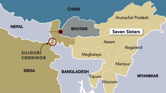
Geography & Location:
- Location: Northern West Bengal, India.
- Width: Approximately 22 kilometers at its narrowest point.
- Bordering Nations:
- Nepal to the west.
- Bhutan to the north.
- Bangladesh to the south.
- Connectivity: Links India’s Northeastern Region (NER), comprising eight states:
- Arunachal Pradesh, Assam, Manipur, Meghalaya, Mizoram, Nagaland, Sikkim, and Tripura, to the rest of India.
Significance of the Siliguri Corridor:
The Chicken’s Neck Corridor is often referred to as India’s Achilles’ heel due to its geopolitical sensitivity and strategic value.
Why It’s So Important:
- Critical for Connectivity: Acts as the sole land link between mainland India and its Northeast.
- Military Movement: Essential for the deployment of troops, supplies, and defense equipment to the northeast, especially in the event of conflict.
- Economic Lifeline: Facilitates the movement of goods and essential supplies between the Northeast and the rest of India.
Proximity to China:
- Located near the India-China border, particularly the Chumbi Valley in Tibet.
- China has built significant military infrastructure in the region, raising concerns about the corridor’s security and accessibility.
- In case of conflict, China could potentially cut off India’s access to its northeastern states by targeting this corridor.
Latest Developments & News:
Recently, Bangladesh has invited China to invest in a river conservation project near the Chicken’s Neck Corridor. This development raises geopolitical concerns for India due to the involvement of China in an area so close to its sensitive border region.
Historical Context & Challenges:
- Partition of 1947: The creation of East Pakistan (now Bangladesh) left the Siliguri Corridor as India’s only land bridge to the northeast.
- Geographical Vulnerability: Its narrow width makes it highly susceptible to blockades or disruption, whether by natural calamities or external threats.
- Infrastructure Challenges: Ensuring uninterrupted connectivity through the corridor requires constant monitoring and development of roads, railways, and communication networks.
Additional Facts & Knowledge:
- Alternative Connectivity: India has been actively working on the Kaladan Multi-Modal Transit Transport Project and the Agartala–Akhaura rail link to improve connectivity with the Northeast via Bangladesh.
- New Rail Links: Indian Railways is developing broad-gauge rail connectivity to the Northeast through the corridor to strengthen supply lines.
- Strategic Concerns: Any blockade or disruption could severely impact India’s national security and economic stability.
- Economic Growth Potential: Enhanced connectivity through the corridor is crucial for boosting trade and development in the Northeastern Region.
The Chicken’s Neck Corridor remains a strategic chokepoint for India. With the involvement of China in projects nearby, the importance of securing and developing the corridor has become more crucial than ever.
6. Kasampatty Sacred Grove: A Jewel of Biodiversity and Culture
Context: The Kasampatty Sacred Grove, also known as the Veera Kovil Sacred Grove, is a sacred and ecologically rich site nestled in Kasampatty village of Dindigul District, Tamil Nadu. This sacred grove has recently been notified as a Biodiversity Heritage Site by the Tamil Nadu government, underscoring its significance in preserving both natural heritage and cultural values.
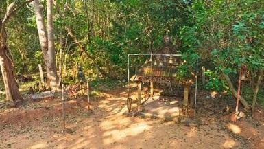
A Glimpse into Kasampatty Sacred Grove :
- Location: Kasampatty Village, Dindigul District, Tamil Nadu
- Area: 4.97 hectares
- Proximity: Near the Alagarmalai Reserve Forest, surrounded by lush mango plantations that enrich the grove’s fertility.
Flora and Fauna of the Grove:
The Kasampatty Sacred Grove is a biodiversity hotspot, hosting a wide variety of species:
- 48 plant species, including rare and medicinal varieties.
- 22 shrub species and 21 lianas (woody vines).
- 29 herb species that contribute to the grove’s ecological balance.
- Over 12 bird species, small mammals, reptiles, and numerous insects, showcasing its genetic richness and ecosystem diversity.
This extraordinary diversity makes the grove a critical site for conservation and environmental education.
Biodiversity Heritage Sites (BHS): A National Effort to Protect Nature
A Biodiversity Heritage Site (BHS) is a unique and highly valued ecosystem with extraordinary biodiversity. These sites are recognized for their cultural, ecological, and aesthetic significance.
Key Characteristics of BHS:
- Richness of Species: Both wild and domesticated species, along with intra-specific categories.
- High Endemism: Presence of species found nowhere else.
- Rare and Threatened Species: Including keystone species and species with evolutionary significance.
- Cultural Significance: BHS sites have important cultural, ethical, or aesthetic values, sometimes linked to long-standing human association with the land.
- Fossil Beds: Some sites feature remnants of preeminent biological components, like ancient fossils.
Kasampatty Sacred Grove’s Designation as a BHS:
- Tamil Nadu Government declared the Kasampatty Sacred Grove as the state’s second BHS under the Biological Diversity Act, 2002.
- This designation helps protect the biological diversity and ensures sustainable management of the site while respecting the cultural heritage of the local community.
Understanding the Biological Diversity Act, 2002:
The Biological Diversity Act, 2002, empowers state governments to designate areas as Biodiversity Heritage Sites in consultation with local bodies. This act aims to:
- Conserve biodiversity and prevent the degradation of ecosystems.
- Enhance the quality of life for local communities through sustainable practices.
- Ensure that local traditions and practices are respected while maintaining the grove’s ecological health.
Historical Context and Future of Kasampatty Sacred Grove:
- The grove’s sacred status has long been respected by the local community, who have nurtured its ecological richness through spiritual practices.
- The Tamil Nadu government’s move to protect this site enhances efforts to preserve the grove’s biodiversity and cultural significance.
Additional Facts and Knowledge:
- Sacred Groves in India: India is home to over 13,000 sacred groves, each preserving local flora and fauna, representing a unique blend of cultural reverence and ecological importance.
- Biodiversity Importance: Protecting sacred groves like Kasampatty ensures the continuation of traditional ecological knowledge, which is crucial for the conservation of endangered species and ecosystems.
- Cultural Significance: These groves have been places of worship and spiritual significance for centuries, fostering a deep connection between nature and culture.
The Kasampatty Sacred Grove stands as a testament to the harmonious relationship between nature and culture. Its new status as a Biodiversity Heritage Site marks a significant step in preserving India’s natural heritage and protecting the invaluable species that call it home.


