30 June 2025 Daily Current Affairs
1. India’s Startup Ecosystem Booms with Innovation and Global Ambition: Meta Report
Context: India’s startup ecosystem has undergone a transformational journey over the past decade, evolving into one of the largest and most dynamic innovation hubs globally. According to a recent report by Meta, this vibrant landscape has witnessed unprecedented growth, driven by technological innovation, supportive policies, and growing investor interest.

Six Key Growth Drivers Powering Indian Startups
The Meta report identifies six strategic levers that are accelerating the rise of India’s startups:
- Artificial Intelligence (AI) Adoption: Over 70% of startups are integrating AI into core business operations, especially in sectors like healthcare, edtech, and beauty. These businesses are leveraging AI for automation, predictive analytics, and hyper-personalised user experiences.
- Cross-Border Expansion: Indian startups are increasingly setting sights on international markets, exporting tech solutions and digital services to North America, Southeast Asia, and Africa.
- Omnichannel Presence: Startups are merging digital and physical platforms, using e-commerce, retail stores, and social commerce to ensure a seamless customer journey.
- Tier 2 and Tier 3 Market Penetration: Smaller cities are becoming key growth areas. Startups are capitalizing on these markets through vernacular content, regional influencers, and WhatsApp-based commerce. Service-based startups are particularly agile in reaching these regions earlier than traditional product-based companies.
- Category Diversification: Entrepreneurs are venturing beyond traditional tech, expanding into clean energy, agritech, fintech, mobility, and social impact sectors.
- Creator-Led Brand Building: Digital creators and influencers are becoming brand ambassadors and co-founders, turning personal brands into scalable businesses with loyal audiences.
India: A Global Startup Powerhouse
- India ranks 3rd globally in the number of tech startups, trailing only the United States and China.
- Over 1.4 lakh startups are currently operating in India, with 30,000+ tech startups.
- As of January 2025, the number of DPIIT-recognised startups has skyrocketed to 1,59,157, up from just 500 in 2016.
- In 2024 alone, India produced 6 new unicorns — privately-held startups valued at over $1 billion.
Massive Employment & Economic Contributions:
- From 2016 to 2024, Indian startups have created over 16.6 lakh (1.66 million) direct jobs.
- Startups also generate millions of indirect jobs through supply chains, logistics, and ancillary services.
- India is now the fourth-largest recipient of global tech startup funding, after the US, UK, and China.
- Startups have significantly boosted GDP growth by driving productivity through innovation and developing supportive ecosystems in finance, logistics, and infrastructure.
Startups Driving Social Impact and Inclusivity:
Startups are playing a pivotal role in bridging rural-urban divides:
- Rural-centric platforms are improving healthcare, education, and agriculture using low-cost technology.
- Women entrepreneurs and social enterprises are emerging strongly in Tier 2/3 cities, enhancing financial inclusion and community resilience.
Strong Policy Backing: Government Initiatives Fueling the Boom
The Indian government has launched several initiatives to nurture and sustain the startup ecosystem:
- Startup India (2016): A flagship initiative offering tax benefits, funding support, and regulatory ease.
- Startup India Seed Fund Scheme (SISFS, 2021): Provides financial aid for prototype development, market entry, and product commercialization.
- Credit Guarantee Scheme for Startups (CGSS): Eases access to collateral-free loans from banks and NBFCs.
- Atal Innovation Mission (AIM): Fosters a culture of innovation via Atal Tinkering Labs, Incubation Centres, and Community Innovation Hubs.
- MeitY Startup Hub (MSH): Centralizes efforts in emerging technologies, linking incubators and Centres of Excellence.
- IndiaAI Mission (2024): With a ₹10,300 crore budget over five years, the mission aims to create India’s own AI infrastructure, including 18,693 GPUs, domestic Large Language Models (LLMs), and problem-specific AI tools.
- Digital Public Infrastructure (DPI): Combines public funding with private innovation to power India’s digital transformation, especially in fintech, identity, health, and commerce.
Future Outlook: Smarter, Inclusive, Global:
India’s startup ecosystem is moving into a mature phase, with a sharper focus on:
- AI-led and deep-tech innovation
- Global expansion and cross-border digital trade
- Sustainability, green tech, and ESG goals
- Hyper-personalization to meet evolving consumer expectations
- Inclusive entrepreneurship from villages to metro cities
Did You Know?
- India has more than 100 unicorns, with over 60,000+ active angel investors.
- Bengaluru, Delhi NCR, Mumbai, Hyderabad, and Pune form the top five startup hubs.
- Indian startups like Zerodha, BYJU’S, Razorpay, and Swiggy have redefined their sectors and gained global recognition.
- India’s DPI models, such as UPI and Aadhaar, are being studied and replicated by other countries.
Conclusion: A Nation of Innovators
India’s startup revolution is not just a tech story—it’s a reflection of a new entrepreneurial spirit, merging technology, inclusivity, and global ambition. As the ecosystem matures, it promises to drive sustainable development, economic resilience, and digital empowerment for over a billion people. The next decade could well position India as the world’s innovation epicenter.
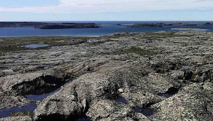
2. Nuvvuagittuq Greenstone Belt: A Glimpse Into Earth’s Earliest History
Context: In a groundbreaking scientific breakthrough, researchers have confirmed that rocks from the Nuvvuagittuq Greenstone Belt in Quebec, Canada, are approximately 4.16 billion years old. This makes them some of the oldest known rocks on Earth, surpassing previous estimates and rivaling formations like the Acasta Gneiss Complex (about 4 billion years old).
This extraordinary age was confirmed using two independent radiometric dating techniques, which track the decay of radioactive isotopes to determine geological timelines.
What is the Nuvvuagittuq Greenstone Belt?
Located on the eastern shore of Hudson Bay in the Nunavik region of Quebec, the Nuvvuagittuq Greenstone Belt is a small but incredibly important zone of ancient geological formations. These rocks are believed to have formed during the planet’s Hadean Eon, just a few hundred million years after the Earth formed about 4.5 billion years ago.
This region holds vital clues to the Earth’s early crustal development, especially since most of the planet’s original rocks were recycled or destroyed by tectonic activity, volcanism, and erosion.
Why Are These Rocks So Important?
- Rocks older than 4 billion years are extremely rare, making any discovery of such age scientifically invaluable.
- The Nuvvuagittuq rocks offer insights into early Earth processes, including the formation of the first continental crust, mantle dynamics, and the conditions under which life may have originated.
- Some researchers even suggest that chemical signatures in these rocks may hint at early microbial life, though this remains a subject of debate.
Cultural and Environmental Significance:
The site lies on Inuit tribal lands near Inukjuak, and is governed by the Pituvik Landholding Corporation. In light of:
- Environmental degradation from previous research,
- Concerns over unauthorized sale of rock samples, and
- The need to protect their heritage,
the local Inuit community has restricted further sampling. Instead, they are seeking to collaborate with scientists to establish a provincial park that will protect the area while allowing responsible scientific exploration.
This approach aims to balance conservation with discovery, setting a model for ethical research practices in indigenous and ecologically sensitive regions.
Ultramafic Rocks: The Earth’s Deep Origins
The Nuvvuagittuq Belt includes ultramafic rocks, which are:
- Rich in magnesium (MgO) and iron (FeO),
- Low in silica,
- Dark-colored, and
- Typically composed of over 90% mafic minerals.
These rocks are closely related to the Earth’s mantle composition and are found in orogenic belts—regions shaped by mountain-building tectonic events.
Studying ultramafic rocks helps geologists understand:
- Mantle dynamics,
- Plate tectonics, and
- The formation of early crust and oceanic plates.
Did You Know?
- The term “Greenstone Belt” refers to regions composed largely of metamorphosed volcanic and sedimentary rocks, often rich in gold and other minerals.
- The Nuvvuagittuq Belt may contain chemical signatures linked to hydrothermal activity, similar to that found around modern deep-sea vents, where life is thought to possibly have originated.
- Earth’s early history is often called the “dark age” of geology because so few rocks from that time survive—making every such discovery a window into our planet’s infancy.
Conclusion: Unearthing the Secrets of Earth’s Birth
The Nuvvuagittuq Greenstone Belt stands as a natural time capsule, preserving the geological secrets of a time long before continents, oceans, or life as we know it. As science advances, and with the respectful collaboration of local Indigenous communities, this ancient terrain could unlock the deepest chapters of Earth’s history—from planet formation to early life.
3. Jellyfish Blooms Rising Along Indian Coasts: A Growing Ecological Concern
Context: Jellyfish, some of the oldest living marine organisms on Earth, have been drifting through the oceans for over 500 million years. These gelatinous, soft-bodied creatures belong to the phylum Cnidaria, a group that also includes corals, sea anemones, and hydras.

Recent scientific studies have reported a sharp increase in jellyfish blooms along the Indian coastline, raising concerns for marine biodiversity, fisheries, and coastal industries.
Anatomy and Adaptability: Simplicity is Their Strength
Jellyfish are remarkably simple invertebrates, yet highly adaptable survivors in diverse marine environments. Their bodies are structured with:
- Radial symmetry, allowing them to respond to stimuli from all directions,
- A three-layered body plan consisting of:
- Epidermis (outer skin),
- Mesoglea (a thick, jelly-like middle layer),
- Gastrodermis (inner layer that lines the gut),
- No brain, heart, or blood, but a nerve net that helps them respond to light and touch,
- Stinging tentacles equipped with specialized cells called cnidocytes, used for both defense and capturing prey.
They use a method of jet propulsion to move through the water, contracting their bell-shaped bodies to push themselves forward.
Ecological Role and Impact:
In ocean ecosystems, jellyfish are both predators and prey. They consume plankton, small fish, and larvae, while also serving as food for species like sea turtles, sunfish, and certain seabirds.
However, under favorable conditions, jellyfish populations can explode into massive blooms, causing ecological and economic disruptions. These blooms are often linked to:
- Climate change and ocean warming,
- Overfishing of jellyfish predators,
- Pollution and nutrient runoff, especially from agricultural activities,
- Coastal development and artificial structures which offer new breeding grounds.
Negative Impacts of Jellyfish Blooms:
Large jellyfish blooms can:
- Disrupt marine food webs, reducing biodiversity and competing with native fish species,
- Collapse fish stocks by feeding on fish eggs and larvae,
- Damage aquaculture farms and block fishing nets,
- Clog power plant intakes, causing operational shutdowns,
- Hurt tourism, as beachgoers avoid areas with stinging jellyfish.
In India, recent blooms have been reported from Goa, Andhra Pradesh, and parts of the Tamil Nadu and Kerala coasts, with scientists attributing these events to rising sea surface temperatures and nutrient-rich runoff.
Did You Know?
- Some jellyfish species are bioluminescent, meaning they glow in the dark!
- The Turritopsis dohrnii, often called the “immortal jellyfish,” can revert to its juvenile stage and start its life cycle anew.
- Despite their name, jellyfish aren’t fish at all—they lack bones, a backbone, or even complex organs.
Conclusion: A Delicate Balance in the Oceans
Jellyfish are not just fascinating creatures—they are important indicators of ocean health. Their increasing blooms along the Indian coast reflect deeper issues like marine pollution, climate change, and overfishing.
As we navigate the future of our oceans, it’s vital to monitor jellyfish populations, implement sustainable coastal practices, and foster marine ecosystem resilience to maintain balance in our blue planet.
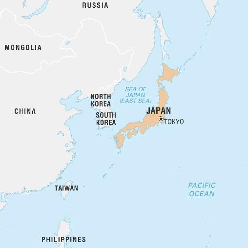
4. Japan in the News: Land of Islands, Volcanoes, and Vibrant Resilience
Context: Japan, with its capital Tokyo, is once again making headlines as earthquakes continue to shake its island chain, a reminder of the nation’s location along the volatile Pacific Ring of Fire. Despite these challenges, Japan remains a symbol of resilience, innovation, and cultural richness.
Political and Maritime Overview:
Located off the eastern coast of Asia, Japan is a sovereign island nation comprised of four major islands:
- Honshu – the largest and most populous,
- Hokkaido – to the north, known for its snowy landscapes,
- Kyushu – in the southwest, rich in historical sites and hot springs,
- Shikoku – the smallest, famed for its scenic beauty and temples.
Maritime Borders of Japan include:
- East – the vast Pacific Ocean,
- North – the Sea of Okhotsk,
- West – the Sea of Japan (also referred to as the East Sea),
- Southwest – the East China Sea.
Japan has one of the world’s most advanced maritime defense strategies, given its location and strategic importance in the Indo-Pacific region.
Geography and Natural Wonders:
Japan’s geography is defined by its rugged terrain, volcanoes, and beautiful landscapes:
- Highest Peak: Mount Fuji (3,776 meters), an iconic stratovolcano and sacred symbol of Japan.
- Major Rivers:
- Shinano River – the longest river in Japan,
- Tone River – crucial for irrigation and hydroelectric power,
- Kiso River – known for its scenic valleys.
Japan’s natural beauty includes dense forests, hot springs (onsen), and thousands of small islands stretching from the Kurils to the Ryukyus.
Frequent Natural Hazards: Living with Earthquakes
Japan lies on the convergence of four tectonic plates, making it one of the most seismically active countries on Earth. The nation faces:
- Frequent earthquakes, including undersea quakes that can trigger tsunamis,
- Volcanic eruptions, especially from peaks like Sakurajima, Asama, and Fuji,
- Typhoons, particularly during the late summer and early autumn.
Despite these hazards, Japan has developed world-leading disaster preparedness systems, with strict building codes, early warning technologies, and community drills that have saved countless lives.
Did You Know?
- Japan is home to over 100 active volcanoes, accounting for 10% of the world’s active volcanoes.
- Tokyo is one of the world’s most populous metropolitan areas, with over 37 million people in its urban agglomeration.
- Japan’s bullet trains (Shinkansen) can withstand strong earthquakes and stop safely in seconds.
Conclusion: Harmony Between Nature and Innovation
Japan is a nation where ancient traditions blend seamlessly with cutting-edge technology. While natural hazards like earthquakes are part of daily life, the country continues to lead the world in engineering, resilience, and innovation. As Japan remains in the global spotlight, it stands not only as a land shaped by nature but as one that constantly adapts and thrives amidst it.
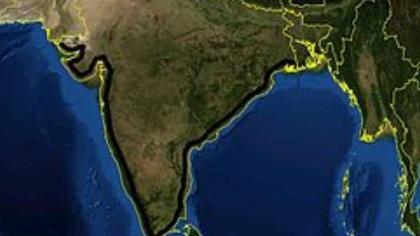
5. India’s Coastline Now Measures Over 11,000 km: Precision Mapping Reveals Hidden Extent
Context: In a remarkable development, India’s total coastline has been recalculated to 11,098 km, up from the previously accepted figure of 7,516 km. This nearly 48% increase does not indicate territorial expansion, but is the result of enhanced mapping precision using advanced geospatial tools and high-resolution satellite data.
Why the Change? The Power of Precision Mapping
The earlier coastline measurement was based on low-resolution data at a scale of 1:4,500,000, which smoothed over minor curves and natural irregularities in the shoreline. With the adoption of high-resolution data at a scale of 1:250,000, the newer mapping captures every bend, indentation, and tidal feature, resulting in a significantly longer measured length.
- Old Method: Manual and less detailed, missing minor features.
- New Method: GIS-based, more accurate, and technologically advanced.
This is a classic demonstration of the “coastline paradox”—the more precisely you measure a naturally irregular shape, the longer it appears.
Coastline Paradox: Why Lengths Are Never Fixed
The coastline paradox highlights the fact that natural features like coastlines do not have a fixed measurable length, because they are infinitely detailed at smaller and smaller scales. As resolution increases:
- More shoreline features are captured, increasing the overall length.
- The measurement is more accurate, though still not absolute.
This paradox applies beyond coastlines, affecting the measurement of river banks, glacier edges, and mountain ridgelines as well.
Inclusion of Offshore Islands Boosts Measurement:
Another major factor behind the revised coastline length is the updated count and mapping of offshore islands, many of which were:
- Unidentified in older records,
- Or missed due to low-resolution imaging and outdated criteria.
The final updated island count now stands at:
- 1,298 offshore islands,
- 91 inshore islands,
- Total: 1,389 islands (excluding river islands like those in Assam and West Bengal).
Earlier counts varied: in 2016, the Surveyor General of India listed 1,382 islands, while other government bodies reported fewer due to inconsistent classification methods.
Administrative and Strategic Significance:
Though the physical geography has not changed, this new data carries far-reaching implications:
- Coastal planning and development can now be more data-driven.
- Disaster preparedness, especially for tsunamis and cyclones, becomes more effective with better-defined coastal boundaries.
- Maritime security and surveillance operations benefit from precise mapping.
- Fisheries management, marine conservation, and environmental monitoring are now better supported with detailed data.
Setting a New Norm: Periodic Reassessment Every 10 Years
To ensure ongoing accuracy, India has now institutionalized a coastline reassessment every decade. This aligns with international best practices and allows for:
- Adaptation to natural changes like erosion, accretion, and sea-level rise,
- Integration of emerging technologies such as AI in remote sensing,
- Better coordination between agencies like the Survey of India, ISRO, Coast Guard, and Ministry of Environment.
Did You Know?
- India has the 7th longest coastline in Asia, and ranks among the top 20 globally.
- The Sundarbans Delta region in West Bengal, the world’s largest tidal halophytic mangrove forest, significantly contributes to coastline complexity.
- Coastal states like Gujarat, Andhra Pradesh, and Tamil Nadu have some of the longest state coastlines.
Conclusion: More Than Just Numbers
This refined measurement of India’s coastline and island count reflects more than technological progress—it marks a shift toward data-led governance, environmental accountability, and maritime readiness. While the land hasn’t grown, our understanding of it has deepened—an essential step in sustainable coastal management and national resilience.
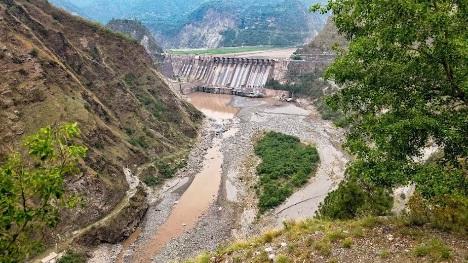
6. India Rejects Arbitration Court Ruling Under Indus Waters Treaty: Reasserts Treaty Integrity
Context: In a firm diplomatic stance, India has rejected the recent supplemental award issued by the Hague-based Court of Arbitration (CoA) concerning the Kishenganga and Ratle hydroelectric projects in Jammu and Kashmir. The court had claimed jurisdiction over disputes related to the design and implementation of these projects. However, India denounced the court as “illegally constituted” and lacking legal legitimacy, reiterating that its establishment violates the provisions of the Indus Waters Treaty (IWT).
The Ministry of External Affairs (MEA) emphasized that India never consented to arbitration, which is a mandatory requirement under the treaty’s dispute resolution framework.
Understanding the Indus Waters Treaty (IWT):
Signed in 1960 between India and Pakistan, with the World Bank as a broker and guarantor, the Indus Waters Treaty governs the use of six rivers of the Indus basin. It is considered one of the most successful water-sharing agreements in the world, despite the strained political relationship between the two nations.
The treaty outlines a three-tiered dispute resolution mechanism:
- Permanent Indus Commission (PIC)
- Consists of one commissioner from each country.
- Handles routine coordination, data sharing, and technical consultations.
- Neutral Expert Mechanism
- For resolving technical differences.
- Either party may request the World Bank to appoint a Neutral Expert, whose decision is binding.
- Court of Arbitration (CoA)
- Can be set up only for legal disputes, requiring mutual agreement by both countries.
- Its use is limited, as it challenges the treaty’s structured and sequential approach to conflict resolution.
India Upholds Neutral Expert Route; Rejects Parallel Proceedings
India has consistently supported the appointment of a Neutral Expert, especially on matters such as design specifications of the Kishenganga and Ratle projects. These include issues like freeboard levels, spillway designs, and pondage limits—technical in nature, and thus best resolved through expert review.
However, Pakistan bypassed this process, first initiating the Neutral Expert route in 2015, then abruptly demanding arbitration in 2016. India strongly objected to this deviation, asserting that it violates the treaty’s spirit and procedure.
In October 2022, the World Bank controversially initiated both the Neutral Expert process and a Court of Arbitration in parallel—an unprecedented and legally contentious move. India views this as a breach of the IWT’s single-track system for handling disputes.
India’s Legal and Strategic Response:
Following the CoA’s latest ruling, India restated that:
- The court lacks legal standing, having been constituted without India’s consent.
- Its actions and decisions are “null and void” in India’s view.
- India continues to participate actively in the Neutral Expert proceedings, which it deems legitimate and binding under the treaty.
India also defended its decision to temporarily suspend certain treaty obligations after the Pahalgam terror attack in April 2024, in which 26 civilians lost their lives. The MEA termed this a sovereign action, allowed under international law, especially in response to acts of aggression and terrorism.
Pakistan’s Strategy and India’s Counter-Position:
India has accused Pakistan of misusing international legal forums to divert attention from its continued support for cross-border terrorism. The MEA described the CoA proceedings as a “legal charade at Pakistan’s behest” and made clear that resumption of treaty obligations hinges on Pakistan taking credible and irreversible steps to dismantle terror networks.
The longstanding disputes over the Kishenganga (on the Jhelum River) and Ratle (on the Chenab River) projects center around engineering features that Pakistan claims may affect downstream flows—allegations India denies, citing adherence to treaty terms.
India Calls for Treaty Review Amid Changing Realities:
In light of geopolitical shifts, security threats, and climate-induced hydrological changes, India has initiated a broader strategic recalibration of the Indus Waters Treaty:
- Formal notices for treaty modification were issued to Pakistan in January 2023 and September 2024.
- India argues that the 1950s-era treaty needs updating to reflect 21st-century realities, including water security, terrorism, and environmental sustainability.
- Experts also point out the need to integrate climate resilience and digital monitoring systems into the treaty’s functioning.
Did You Know?
- The Indus Waters Treaty has survived three wars between India and Pakistan.
- The Indus basin supports over 300 million people in both countries.
- Kishenganga Project (330 MW) and Ratle Project (850 MW) are part of India’s broader push to harness hydropower in Jammu & Kashmir for clean energy and strategic leverage.
Conclusion: A Pivotal Moment in India-Pakistan Water Diplomacy
India’s rejection of the arbitration court ruling marks a critical turning point in the future of the Indus Waters Treaty. As legal, technical, and strategic challenges mount, the emphasis now shifts to modernising the treaty, defending sovereign interests, and ensuring that legal mechanisms are not misused for political ends.
You may also like
")
03 September 2025 Daily Current Affairs
")
02 September 2025 Daily Current Affairs
")