
1. Early Arrival of Indian Monsoon: IMD Signals Possible Advancement in 2025
Context: The India Meteorological Department (IMD) has recently hinted at a potential early onset of the southwest monsoon, which typically begins over Kerala around June 1. Normally, it takes about 10 days for the monsoon winds to progress from the Nicobar Islands to the southern tip of the Indian mainland. This early onset could have significant implications for agriculture, water management, and disaster preparedness.
Understanding the Indian Monsoon: Natural Engine of South Asia
- The Indian monsoon system is one of the most complex and powerful weather phenomena in the world, driven by multiple interacting climatic forces. Here’s a breakdown of the key mechanisms that generate and sustain the monsoon:
- Land–Sea Thermal Contrast: During summer, the Indian subcontinent heats up more rapidly than the surrounding ocean. This creates a low-pressure zone over land, drawing in moist, cool air from the ocean, which rises and forms rain-bearing clouds.
- Inter-Tropical Convergence Zone (ITCZ): The ITCZ—a low-pressure belt near the equator—shifts northward during the summer. This draws trade winds towards the subcontinent, feeding the monsoon system and enhancing rainfall, especially over the Indo-Gangetic plains.
- Tibetan Plateau’s Role: The elevated Tibetan Plateau becomes intensely heated, forming a thermal low that strengthens vertical air circulation, further intensifying the inflow of moist monsoon winds.
- Tropical Easterly Jet (TEJ): This high-altitude jet stream, active during summer, supports the monsoon trough, enhancing both rainfall intensity and geographical spread.
Oceanic Influencers: ENSO & Indian Ocean Dipole (IOD)
El Niño–Southern Oscillation (ENSO):
- El Niño: Warms the central Pacific Ocean, typically weakening the Indian monsoon.
- La Niña: Cools Pacific waters and is often linked with enhanced monsoon rainfall.
Indian Ocean Dipole (IOD):
- Positive IOD: Warmer waters in the western Indian Ocean boost monsoon rains.
- Negative IOD: Leads to drier conditions and weaker monsoons over India.
Stages of the Monsoon: From Onset to Withdrawal
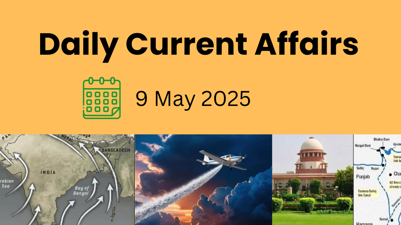
Arabian Sea Branch:
- Arrives over Kerala by June 1, moves up the west coast, soaking regions like Goa, Maharashtra, and the Western Ghats.
Bay of Bengal Branch:
- Hits Northeast India in early June, then spreads across the Indo-Gangetic plains. The entire country is generally covered by mid-July.
Monsoon Retreat:
- Begins from northwestern India in October. The shift in winds causes “October Heat”—hot, humid conditions after rainfall ceases.
- Brings post-monsoon rains to southeastern India, especially Tamil Nadu and Andhra Pradesh.
Monsoon’s Impact: Lifeline of India:
Agriculture:
- Powers the Kharif cropping season, especially for rice, maize, and pulses.
- Over 50% of Indian farmland is rain-fed, making monsoon performance crucial for food security.
Economy:
- Monsoon-driven agriculture affects GDP, inflation, rural incomes, and employment.
Water & Energy:
- Recharges rivers, lakes, aquifers, and hydroelectric dams, providing water for drinking, irrigation, and electricity generation.
Biodiversity & Culture:
- Sustains forests, wetlands, and ecosystems.
- Central to cultural traditions, festivals, and folk practices celebrating rain.
Disasters:
- Excess rainfall often causes floods, landslides, and urban waterlogging—especially in vulnerable, densely populated regions.
Scientific Progress: Strengthening Forecast Accuracy:
Monsoon Mission (2012):
- Launched by the Ministry of Earth Sciences, this mission focuses on improving dynamical modeling for better medium and long-term monsoon forecasts.
National Supercomputing Mission:
- Supports high-performance computing capabilities to run complex weather models for more accurate monsoon predictions.
IMD–ICAR Collaboration:
- Delivers Agrometeorological Advisory Services to farmers, offering region-specific weather forecasts and farming advice to boost climate resilience in agriculture.
Did You Know?
- The Indian monsoon directly affects nearly 70% of India’s population, especially those involved in agriculture.
- A “normal monsoon” delivers 96% to 104% of the Long Period Average (LPA) rainfall, currently pegged at 87 cm.
- 2022 and 2023 saw erratic monsoon patterns due to back-to-back La Niña and El Niño cycles.
Looking Ahead:
An early monsoon in 2025 could bring early sowing opportunities for farmers but may also pose risks of intense early flooding or pest outbreaks. It underscores the importance of scientific preparedness, policy responsiveness, and climate adaptation strategies in an era of growing weather unpredictability.
2. Sutlej-Yamuna Link (SYL) Canal Dispute: A Legal and Political Stalemate
Context: The long-standing Sutlej-Yamuna Link (SYL) Canal dispute has once again resurfaced, with the Supreme Court strongly criticising Punjab for its unilateral decision to de-notify land acquired for the canal’s construction. The apex court termed the move an act of “high-handedness,” reiterating its earlier directive to maintain status quo on the canal-related land and infrastructure.
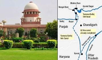
What is the SYL Canal and Why is it Controversial?
The SYL Canal, proposed to facilitate the equitable distribution of water from the Ravi and Beas rivers, was intended to address water needs of the states of Punjab, Haryana, and Rajasthan.
- The planned length of the canal was 214 km, with 122 km in Punjab and 92 km in Haryana.
- However, decades later, the project remains incomplete due to legal challenges, political opposition, and inter-state tension.
Timeline of the SYL Canal Dispute:
- 1981 Agreement: A tripartite agreement between Punjab, Haryana, and Rajasthan laid the foundation for sharing Ravi-Beas waters and constructing the SYL canal.
- 1996: Haryana filed a suit in the Supreme Court demanding Punjab complete its share of canal construction.
- 2002: The Supreme Court ruled in favour of Haryana, directing Punjab to proceed with the canal.
- 2004: Punjab passed the Punjab Termination of Agreements Act, aiming to annul all prior water-sharing agreements.
- 2016: A Constitution Bench struck down the 2004 Act, declaring it unconstitutional.
- 2024–25: Punjab’s latest de-notification of SYL land has triggered fresh judicial scrutiny.
Recent Supreme Court Directions:
- The Supreme Court appointed the Union Home Secretary, Chief Secretary of Punjab, and Punjab’s DGP as Receivers to manage land-related issues.
- The court stressed the need for mutual consensus among Punjab, Haryana, and the Centre.
- If unresolved, the matter will return to the bench on August 13.
Legal Framework for Inter-State Water Disputes in India:
Under Article 262 of the Indian Constitution, Parliament is empowered to enact laws to resolve inter-state river water disputes, and once a tribunal is formed under this provision, courts are barred from intervening.
Key Legislations:
- River Boards Act, 1956: Allows the Centre to form river boards with states, though no board has ever been created.
- Inter-State River Water Disputes Act, 1956 (ISRWD): Provides for formation of tribunals upon states’ request; amended in 2002 to mandate:
- Tribunal formation within one year
- Decision within five years
- Awards carry the weight of a Supreme Court order
- Clarification window of 3 months
Persistent Issues with Tribunals:
- Delays: Disputes often drag on for decades. For instance, the Cauvery Water Disputes Tribunal took 17 years (1990–2007).
- Implementation Gaps: States resist enforcement of tribunal awards.
- Judicial Overlap: Despite constitutional limits, states invoke Article 136 and Article 32 to challenge awards in the Supreme Court.
- Lack of Technical Input: Tribunals often lack scientific expertise, being dominated by judges.
- Opaque Water Data: States often withhold or manipulate hydrological data, impeding fair judgment.
- Federal Complications: Bureaucratic overlaps between state and central agencies slow the process.
Proposed Reforms for Speedy and Fair Dispute Resolution:
Inter-State River Water Disputes (Amendment) Bill, 2019:
- Proposes a permanent tribunal for all inter-state river disputes.
- Introduces a Dispute Resolution Committee (DRC) to promote pre-tribunal negotiation.
- Recommends inclusion of hydrologists, ecologists, and engineers as technical members.
- Suggests creation of an independent water data authority under the Central Water Commission (CWC).
Emphasis on Alternative Dispute Resolution (ADR):
- Encourages mediation and negotiation by neutral parties or the Union Government as a means of amicable and faster settlement.
The Bigger Picture:
The SYL canal case is more than just a regional infrastructure issue—it embodies the challenges of federalism, environmental stress, and political mistrust in water governance. With climate change exacerbating water scarcity, resolving such disputes with science-based, transparent, and time-bound mechanisms is now more urgent than ever.
3. Revised SHAKTI Policy: Powering India’s Energy Security with Transparent Coal Allocation
Context: The Cabinet Committee on Economic Affairs (CCEA) has approved a major revamp of the SHAKTI Policy (Scheme for Harnessing and Allocating Koyala Transparently in India), aiming to streamline coal allocation and energize the power sector with improved transparency, accessibility, and efficiency.
SHAKTI Policy: A Shift Towards Transparent Coal Allocation
Launched in 2017, the SHAKTI policy marked a pivotal transition from the earlier nomination-based coal linkage system to a more transparent, auction and tariff-based allocation mechanism. The latest revision of the SHAKTI policy brings in a host of innovative features, aiming to:
- Broaden eligibility for coal allocation
- Provide greater flexibility in the linkage mechanism
- Ensure enhanced access to coal for all power producers
These changes will lead to increased power generation, lower electricity tariffs, and a boost to economic productivity by ensuring a reliable supply of fuel to power plants.
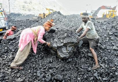
India’s Coal Sector: Backbone of the Power Industry
Coal continues to be the cornerstone of India’s energy mix, playing a critical role in the nation’s development.
- Record Production: India crossed the 1 billion tonne production mark in FY 2024–25, registering a 4.99% annual growth.
- Global Ranking: India is the second-largest coal producer and consumer in the world.
- Reduced Import Dependency: Coal imports fell by 8.4%, saving foreign exchange and reducing vulnerability to global price fluctuations.
- Dominant Energy Source: Coal contributes nearly 55% of India’s energy supply and powers over 74% of electricity generation.
Key coal-producing regions include Jharkhand, Odisha, West Bengal, Chhattisgarh, and Madhya Pradesh.
Economic Importance of the Coal Sector:
- Rail Freight: Coal is the largest freight commodity for Indian Railways, contributing 49% of total freight revenue.
- Government Revenue: The sector yields over 70,000 crore annually through royalties, GST, and levies.
- Employment Generator: Employs over 239,000 workers in Coal India Ltd (CIL) and thousands more through contractors and logistics networks.
Major Challenges in India’s Coal Landscape:
Despite its dominance, India’s coal sector grapples with several persistent issues:
- Environmental Concerns: High carbon emissions, air pollution, and ecosystem degradation from mining activities.
- Import Dependency: Continued need for coking coal and high-grade thermal coal, despite large domestic reserves.
- Regulatory Delays: Slow land acquisition and environmental clearances delay coal block development.
- Underutilization: Mining operations often run below capacity due to demand fluctuations and infrastructure issues.
- Climate Commitments: India’s Net Zero by 2070 goal puts pressure to phase down coal usage.
- Limited Private Sector Role: The sector is dominated by PSUs, limiting competition and innovation.
Government Initiatives to Modernize the Coal Sector:
To address these challenges, several forward-looking reforms have been introduced:
- Commercial Coal Mining (2020): Allows private players to mine and sell coal without end-use restrictions—promoting competition and self-sufficiency.
- Single Window Clearance Portal (2021): Speeds up approval processes for land, forest, and environment clearances.
- Auction for Non-Regulated Sectors: Coal blocks are auctioned for use in steel, cement, aluminum, etc., expanding the market.
- Coal Gasification Target: India plans to gasify 100 million tonnes of coal by 2030, reducing pollution and diversifying coal usage.
- Technology Upgrades: Drones, GPS tracking, automated loading, and online coal sale portals increase transparency and safety.
- Coal Logistics Modernization: Dedicated freight corridors and first-mile connectivity projects improve coal transport efficiency.
- Access for SMEs: Through e-auctions, even small industries can procure coal at market-linked prices, enhancing inclusivity.
Conclusion: A Balanced Path Towards Energy TransitionWhile coal remains vital for India’s short- to mid-term energy security, a strategic and balanced transition toward cleaner energy is imperative. The revised SHAKTI policy reflects the government’s intent to strengthen domestic production, enhance transparency, and support power affordability. It aligns with the broader vision of Viksit Bharat—an energy-secure, self-reliant, and sustainable India.
4. Cloud Seeding in NCR: Delhi Launches High-Tech Battle Against Air Pollution
Context: In a bold move to combat severe air pollution, the Delhi Cabinet has approved a 3.21 crore project to conduct five cloud-seeding trials across the National Capital Region (NCR). This decision marks a significant technological intervention aimed at improving air quality through artificial rainfall generation.

What is Cloud Seeding?
Cloud seeding is a weather modification technique designed to enhance rainfall by artificially stimulating precipitation. It works by dispersing substances into the atmosphere that encourage cloud droplets to coalesce and fall as rain.
How it Works:
- Seeding agents such as silver iodide, potassium iodide, dry ice, or liquid propane are dispersed using aircraft, rockets, or ground-based generators.
- These particles act as condensation nuclei, encouraging moisture in clouds to form droplets large enough to precipitate.
- The method is also used to suppress hailstorms, reduce dust, and clear particulate matter, improving air quality.
Ideal Conditions for Successful Cloud Seeding:
Cloud seeding cannot create clouds—it can only enhance precipitation from existing cloud systems. The effectiveness depends on several meteorological factors:
- Cloud Type and Depth: The cloud must be sufficiently thick and have the right moisture content.
- Temperature Range: Optimal conditions exist when cloud temperatures are between -10°C and -12°C, allowing the seeding agents to form ice crystals.
- Wind Speed: Wind must be moderate to prevent dispersal of the seeding material away from target areas.
- Topography: Hilly and mountainous regions are particularly suited for effective seeding due to better cloud formation and moisture dynamics.
Challenges and Concerns:
Despite its promise, cloud seeding comes with scientific, environmental, and ethical concerns:
- Chemical Impact: The use of agents like silver iodide may pose risks to soil and water quality, potentially affecting agriculture and drinking water sources.
- Rain Redistribution: Inducing rainfall in one area might inadvertently reduce natural rainfall in neighboring regions, leading to localized droughts.
- High Operational Costs: The technology requires advanced aircraft, skilled meteorologists, and precise coordination, making it a resource-intensive process.
Why Cloud Seeding for Delhi?
Delhi’s air quality regularly plunges to hazardous levels, especially during winter months when stubble burning, vehicle emissions, and low wind speeds combine to create a toxic smog blanket. Cloud seeding offers a temporary but immediate solution:
- It can help settle airborne pollutants by encouraging rainfall.
- Provides respite during critical pollution spikes when other mitigation strategies fall short.
The Way Forward: Technology as Part of a Larger Solution
While cloud seeding may offer short-term relief, experts stress that it must not be seen as a standalone fix. A multi-dimensional strategy is essential, which includes:
- Stringent emissions control
- Expansion of green spaces and urban forests
- Shift to cleaner fuels and public transport
- Health preparedness for pollution-related diseases
Conclusion:The Delhi government’s decision to embrace cloud seeding is a landmark initiative, combining science and governance in the fight for breathable air. While not a silver bullet, it represents a bold step forward in climate adaptation and urban pollution management.
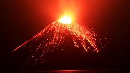
5. Anak Krakatau Volcano: Rising Fury of the ‘Child of Krakatoa’
Context: Anak Krakatau, meaning “Child of Krakatoa,” continues to remind the world of the volatile power lying beneath the Earth’s crust. Recently, satellite radar analysis revealed that the volcano’s deadly 2018 collapse—which triggered a destructive tsunami—was preceded by years of unnoticed ground deformation, highlighting the urgent need for enhanced monitoring of volcanic activity.
Where is Anak Krakatau Located?
- Nestled in the Sunda Strait, between Java and Sumatra in Indonesia, Anak Krakatau is part of the volatile Pacific Ring of Fire—a horseshoe-shaped zone known for its frequent earthquakes and volcanic eruptions. This region houses more than 75% of the world’s active and dormant volcanoes.
Birth of a Volcano: From Krakatoa’s Ashes
- Anak Krakatau emerged from the sea in 1927, following the catastrophic eruption of Krakatoa in 1883, one of the most violent eruptions in recorded history. That eruption produced an explosion heard over 3,000 km away, generated tsunamis over 30 meters high, and killed more than 36,000 people.
- Rising from the submerged remnants of that disaster, Anak Krakatau began its own stages of growth through frequent strombolian eruptions—a volcanic activity pattern marked by regular, explosive bursts of lava.
Eruptions and Geological Activity:
- Since 1963, Anak Krakatau has erupted at least nine times, with most episodes lasting less than a year. It is built on layered deposits of lava, ash, and volcanic rocks, making it a classic stratovolcano with steep sides and powerful eruptions.
The volcano sits atop multiple magma chambers, creating a complex and unstable system that poses significant risks to nearby populations and coastlines.
The 2018 Collapse and Tsunami Tragedy:
- On 22 December 2018, a violent eruption led to the collapse of the volcano’s southwestern flank. The resulting underwater landslide displaced enough material to generate a tsunami, which struck the coasts of southern Sumatra and western Java with little warning, killing over 430 people and injuring thousands.
What makes this event even more tragic is the satellite data revelation: slow deformation of the volcano’s structure had been ongoing for years, but it went largely unnoticed due to lack of detailed monitoring.
Scientific Advances and Monitoring Gaps:
- Recent studies using Interferometric Synthetic Aperture Radar (InSAR) have uncovered pre-eruption ground movement, proving that modern satellite tools can be instrumental in forecasting potential disasters.
- However, Indonesia’s archipelagic geography and limited resources mean that many volcanoes are under-monitored, putting millions at risk.
Did You Know?
- Anak Krakatau grows by several meters every year due to regular eruptions.
- Indonesia has more active volcanoes than any other country, with more than 120 volcanoes currently active.
The region is part of the collision zone between the Indo-Australian and Eurasian tectonic plates, making it one of the most tectonically active areas in the world.
Conclusion: A Living Reminder of Earth’s Power
Anak Krakatau is not just a geological marvel—it is a living, growing reminder of how dynamic and dangerous Earth’s interior can be. While its eruptions offer valuable scientific insights, they also underscore the need for robust early warning systems, international cooperation, and public awareness to reduce future risks.
6. SCALP Missile: Precision Firepower from the Skies
Context: In a strategic show of strength during Operation Sindoor, SCALP missiles were reportedly deployed by Indian Rafale fighter jets to deliver precision strikes on terror infrastructure located deep within Pakistan and Pakistan-occupied Kashmir (PoK). This marks a significant demonstration of India’s long-range strike capability and reinforces its ability to conduct high-value operations with surgical accuracy.
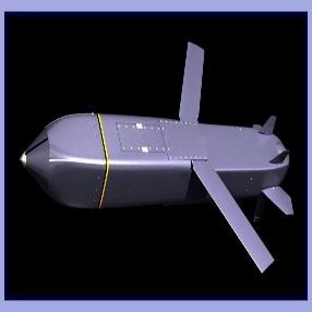
What is the SCALP Missile?
Known internationally as Storm Shadow, the SCALP missile is a long-range, air-launched cruise missile specifically designed for deep strike missions. It is conventionally armed and targets fixed or fortified installations, such as command centers, bunkers, and strategic infrastructure.
The acronym SCALP stands for Système de Croisière Autonome à Longue Portée, or Autonomous Long-Range Cruise System, emphasizing its autonomous targeting capability and extended operational reach.
Origin and Global Use:
- Jointly developed by France and the United Kingdom, SCALP is a product of European defense collaboration under MBDA Systems.
- It is operational in the air forces of India, UK, France, Egypt, Italy, Greece, Saudi Arabia, Qatar, and the United Arab Emirates (UAE).
- India acquired SCALP as part of the Rafale fighter jet deal, giving the Indian Air Force an advanced precision-strike capability over hostile territory.
Key Features of the SCALP Missile:
- Range: Capable of striking targets at a range of approximately 500 km, allowing deep penetration into enemy territory without endangering aircraft.
- Warhead: Carries a 450 kg BROACH warhead (Bomb Royal Ordnance Augmented Charge), designed to pierce hardened shelters and underground bunkers.
- Size & Weight: The missile is around 5 meters in length, has a 3-meter wingspan, and weighs roughly 1,300 kg.
- Stealth & Navigation: Flies at low altitudes using terrain-following radar, INS/GPS navigation, and infrared terminal guidance.
- Precision Targeting: In the terminal phase, the missile’s infrared seeker compares real-time images to pre-programmed target visuals, ensuring pinpoint accuracy with minimal collateral damage.
- Weather Independence: Its sophisticated design enables operation in all weather conditions, day or night.
Launch Platforms and Indian Integration:
The SCALP missile has been custom-integrated into India’s Rafale fleet, significantly expanding the Indian Air Force’s strike envelope. It offers strategic deterrence and the ability to neutralize high-value assets across difficult terrain, including mountainous regions and fortified zones.
Did You Know?
- The SCALP has been combat-tested in Iraq, Syria, and Libya, where it demonstrated high precision and reliability.
- The missile is part of a new generation of stand-off weapons, allowing jets to launch from a safe distance, outside enemy air defense range.
- Its stealthy profile and low radar cross-section make it hard to detect and intercept, even in heavily contested airspace.
Conclusion: A Game-Changer in Modern Warfare
The SCALP missile represents a leap forward in long-range precision warfare, enhancing India’s ability to pre-empt or respond to cross-border threats with surgical precision. Its integration into the Rafale platform reflects India’s commitment to building a technologically superior, responsive, and versatile air strike capability for 21st-century warfare.


